

Our last hike during our Sept/Oct 2020 road trip was to Silver Lake near Telluride, Colorado. It was a tough one and we hiked it on a whim. Our plan was to hike to Blue Lake starting from the top of Bridal Veil Falls. We started on the trailhead and saw the sign also included Silver Lake, which was a shorter distance. We had been day hiking for 11 days and were discussing if we should take the shorter trail to Silver Lake instead of hiking to Blue Lake. A couple over heard us and told us Silver Lake was so beautiful and much less crowded. They did comment that there was a bit of scrambling but not bad. They had us at less crowded! We looked the trail up on All Trails, checked the map, and decided it was a go.
Location
The Trailhead for Silver Lake is near Telluride, Colorado. It is at the top of Bridal Veil Falls. You can reach the top of Bridal Veil Falls by either hiking or taking the 4×4 road. The 4×4 road requires 4 wheel drive and high clearance. We drove up with our Jeep and it was a fun ride! You can follow this link to my post on Bridal Veil Falls if you wish to read about it. You cannot go past the gate at the top so you will have to park along the road. Make sure you park close enough to the side to let other vehicles pass.
Finding Silver Lake Trail
As mentioned before, we had originally planned on hiking to Blue Lake but changed our minds and decided to go for Silver Lake. There is a gate across the road with a sign, which is basically the trailhead for both. Follow the road to access both trails.

Silver Lake is not marked, but is not too far from the gate. I did not measure the distance but I would guess 1/4 mile more or less. There is a creek on the right and you will see a clearing with a a path veering off to the creek and continuing on the other side of the creek. This is your trail to Silver Lake!!


Hiking The Silver Lake Trail
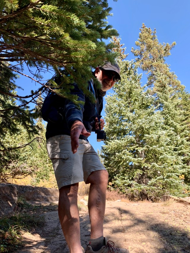
The hike to Silver Lake is rated difficult on All Trails and I am in total agreement. The trail has a lot of loose rock and is slick. Plus you are ascending continuously. Once you find the trail, follow the trail up and to the right. Shortly after we hit the trail we came across some big rock scrambles. I would not say they were hard, but a bit tricky finding good footing. After that continue up and right, towards the top.


There are actually switchbacks, which we didn’t really notice until on our way down, as the trail wasn’t always easy to find. At one point we could see the trail ahead and behind us, but just had to figure out how to get from point A to point B. There are also many false trails that go to nowhere, yup, we followed one or two! Our best way to follow this trail was to find the freshest shoe prints and hope they went the right way! To be honest, this was actually a lot of fun for us!


Where’s the Lake?
Once we reached the trees the path was easier to follow. We did have to climb over a few roots and even climb over and go under downed trees. Lots of tree debris in the path, but not difficult to hike on. Again, just need careful footing.


We came to the end of the trail to a clearing which looked like a place for a lake. There was no lake in sight and no trail. We decided to go left and walked through a makeshift campground and still, no lake. We walked further to the left around the clearing, crossed a tiny trickle of a stream (so we knew there was water somewhere). Still no lake. Back we went to the end of the trail and followed the clearing to the right looking for a lake or a trail.


Suddenly, Steve noticed a faint steep trail climbing up to the mountain top! He was sure that Silver Lake was at the end of that trail! He was right!


Silver Lake
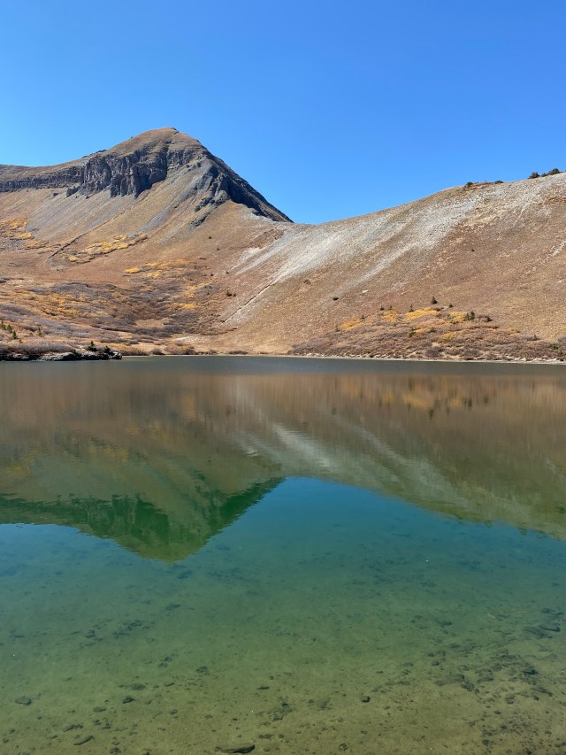
The hike up to Silver Lake from here was not easy. It was steep and the rocky path was slick. I felt like every few feet or so I would slip back a bit. Slowly we made our way to the top. Once on top of the mountain, Silver Lake was there. Much bigger than we thought and oh so pretty. Not only had we not seen anyone since we started this trail, there was not a soul at the lake. Just us! To me, this was the perfect mountain lake. The blue of the water was clear and the mountain peaks mirrored perfectly in the water, in addition, the sun was shining and not a cloud in the sky. I can’t begin to say how awesome it felt to be here.


Steve decided to walk around and take photos and I decided to relax. We were there for about a half hour when a couple came up and went for a swim. Those were the only other people we seen on this entire hike! They mentioned they had been to Blue Lake but it was crowded and much colder. They also mentioned this was prettier. So we were glad we made this choice. Of course, even though I loved Silver Lake, I am already making plans to hike Blue Lake and other lakes around Telluride and Colorado in the future!


Carefully Down the Trail
All good things must end. After snacking and enjoying this beautiful alpine lake we decided to head down. We had no idea how tough the descent would be. I mentioned the slickness of the trail from the clearing to the lake, it was horrible going down. We basically slid about a foot with every step in many places. The other couple that was at the lake came running down and told us if you took quick little running steps you wouldn’t slide. I tried this and thought I was going to face plant so that option was out!


We made it to the clearing and thought we were home free. The walk was easy here and it was all good, or so we though. The walk through the forest was uneventful and the shade felt good as the day had warmed up.
Once out of the trees we could easily see the path going down and clearly saw the switchbacks. We could also see the road to Bridal Veil Falls and even saw people there. The problem was, once again, getting from point A to point B. It was slick in many places. We would be doing just fine and then slip. We never fell, just slid, like on ice. I tried walking sideways, turning one foot to the side, I even tried sliding down on my bottom. There was no easy solution so we just did our best, walked, slid and watched our footing! Very frustrating! I really wished I had brought my trekking poles! Thankfully though, we could see the road getting closer all the time. Once we reached the rock scramble all was good! We crossed the creek and headed to the Jeep!

Conclusion
All trails maps rates his hike as difficult and it is a 2.9 miles round trip. I have seen other sources mark this trail as 3.4 miles round trip. I am not sure if they start at the creek or the gate. My fit bit tracked me at 2.56 miles one way from our Jeep near the Power Plant. We did wander quite a bit so I am sure that is why the discrepancy. It took us 2 hours to get to the top and 1 hour and 45 minutes to return. We spent a little over an hour at the lake.
This is really a great Colorado alpine lake and with Silver Lake being close to Telluride it is fairly easy to get to.
Back to Telluride and Where We Ate
Once back to our Jeep we drove slowly down the switchbacks and back to Telluride. After cleaning up, we spent the rest of the afternoon wandering the town and enjoying the mountain atmosphere.
We ate at the Chop House Restaurant in the New Sheridan Hotel . We were seated at a table in the secluded window area of the restaurant and had an awesome meal.


Resources
Colorado Chelsea, Hikes and Travels in Colorado and Beyond is a great resource for hiking in Colorado. Chelsea lives in Colorado and has blogged about her many different hikes giving great information on each.
All Trails. All trails is a hiking App that gives information on most every hike known. You can use this app to get an idea of where or what type of hike you want to do. Directions are available as well.
Check out my other posts from Colorado below:
Hikes
Royal Arch Trail, Boulder, Colorado September 2020
Flatirons Loop Trail, Boulder, Colorado September 2020
Independence Ghost Town, Colorado October 2020
The Grottos Trail, Aspen, Colorado October 2020
Royal Arch Trail, Boulder, Colorado September 2020
Flatirons Loop Trail, Boulder, Colorado September 2020
Silver Lake, Telluride, Colorado October 2020
Rifle Falls, Colorado September 2020
Odessa and Fern Lakes Aug 2020
St Mary’s Glacier Hike Aug 2017
Jeeping
Crystal Mills in Colorado, September 2020
Road Trips
Our Rocky Mountain National Park Trip Aug 2018
My Favorite Colorado Road Trip Aug 2016
Follow Me on Instagram!!
Discover more from Diary of a Gen-X Traveler
Subscribe to get the latest posts sent to your email.
SW Colorado is so incredibly beautiful. My husband grew up in Durango. Before our wedding, some 26 years ago, we traveled to that area and drove the loop from Durango to Silverton, Telluride, and back to Durango. I would absolutely love to go back again one day.
It is such beautiful country!
Love the pictures!
Thank you!!
Looks like a beautiful hike Lori. Those rocky scree hikes are a challenge. They seem to work on the way up, but the way down can be a slippery slope. That lake is beautiful and it looks like your meal was well earned. Thanks for sharing. Stay well. Allan
Thanks for reading, Allan! It was quite a surprise on the way down!! Lori
Looks beautiful 🙂
Thanks! We loved it!
Beautiful photos ❤️
Thanks!!
Great hike with some adventure.
Thanks! The adventure was fun but glad when we were done!
Wow, that river crossing looks like a tricky feat; I don’t think I would’ve been able to pull it off as dexterously as you did! The views of the mountains, especially covered with the yellow flowers (what are they called?) make for a unique experience, and a nice meal in the end is certainly the perfect finish to a long and arduous hike! Congrats!
I am not sure what the flowers are called. The crossing was not bad. We walked over the rocks and were able to keep our feet dry!! Thanks for reading!
Looks like a beautiful day to go for a hike. Downhills are always my least favourite part of the hike. It’s always feels nice to treat yourself for a nice meal after a long day of hiking.
Downhills are tough! Especially with a steep grade. Those meals at the end keep
Me going!! Something to look forward too!! Take care and thanks for reading!!
I haven’t done this one. I’ll have to check it out this summer!
I bet you would like it!! We want to go back and do more around the Telluride and Ouray area. Probably not this year but next!!
sounds like a challenging hike, but well worth it. some spectacular scenery along the way, and the lake look wonderful.
We really did enjoy this! It was a real
Challenge for us though!!
perhaps the challenge is part of what made it so enjoyable!
That could be! Hope you are feeling better!!
thanks, Lori. I am feeling much better…
Glad to hear that!!😀
Such clear, clear waters — both in the streams and in the lakes. Even I might be tempted to hike with scenery like this.
The water was absolutely pristine looking. It was such a peaceful place.
Merci de nous permettre de suivre vos pas
Merci de suivre
The train ride we took to Telluride from Durango was a magnificent experience.
I hear it is great! I think I rode it as a kid but that would have been back in the 1970’s so
I don’t remember it much!!
I’m a little late to the party but oh wow does this look gorgeous!
It is definitely one of our top hikes of all time! You would love it!