

A hike to Sky Pond, Colorado is a perfect day hike. Definitely tops for trails in Rocky Mountain National Park. Located on the Eastern side of Rocky Mountain National Park. Easy to get to, this trail is located about a half hour from Estes Park, follow Highway 36 W and then take Bear Lake Road.
I love this trail because it offers it all, including climbing up a waterfall! In addition to waterfalls, there are lakes, forests, and alpine ponds. The trail starts at Glacier Gorge Trailhead. It is an 8.5 mile out and back trail, although there are a few variations you can take. Specifically, you can start at other trails which can shorten or lengthen the hike.
Bear Lake

My husband Steve, and I started our hike to Sky Pond at Bear Lake Trailhead, only because the parking was full at Glacier Gorge. I was surprised to see the parking lot full as it was only 7 am! This added roughly 0.5 mile round trip to the hike. Not too bad and anyway, it was a great day for a hike, so what the heck!

Bear Lake is an Alpine lake which is located in Rocky Mountain National Park. It is easy to locate by following highway 36, then taking Bear Lake Road to the end. Whenever I have been to Bear Lake, there has been a Ranger there. The Park Ranger always has a wealth of information on trail conditions, etc. Bear Lake is a beautiful reflective lake and there is a loop trail around it. This trail is surrounded by a forest including some Aspen trees and the trail is less than a mile around. We decided not to do the loop this time as we were excited to hike to Sky Pond.
Alberta Falls

After pausing to admire Bear Lake we started our hike towards the first milestone on our agenda, Alberta Falls. The 1 mile hike from Bear Lake to Alberta Falls is easy. The dirt trail which is well defined, starts down hill and then begins to climb. When you reach the Glacier Gorge Trail, continue to the right at this intersection. If you go left, you will reach the Glacier Gorge Trail Head. It is a lovely walk through the Aspen trees. At times you will hear the rushing water as you walk above Glacier Creek. There was considerable traffic for this early in the morning, although many people only go to Alberta Falls and the traffic slows after that. The falls were spectacular. The roar of the water smashing onto the rocks below and rushing of the creek, added to the enchantment of the falls. Simply beautiful.
Hike to Loch Vale
Continuing on with our hike to Sky Pond, we marched forward to an area called The Loch. Also known as The Lake. The trail continues to incline gradually for the next couple of miles. I would still consider it an easy trail at this point, the path is good and the incline easy. After awhile, you will come across other trails intersecting Glacier Gorge Trail. When you come across the first intersection, continue to your right. If I remember it is marked well as we had no problem finding our way. The next intersection is a 3 way intersection. Go straight if you want to continue to The Loch and Sky Pond. You can chose to take the path on the right to Lake Haiyaha. Eventually it will take you back to Bear Lake the long way.


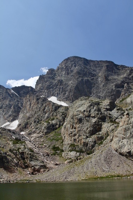
Going forward you will follow The Loch Vale Trail. You will find the trail becomes more rough and noticeably steeper, also be prepared for a few switchbacks. It is a pretty hike as you follow the trail though a gorge giving you occasional views of a mountain creek and even a waterfall. Breaks between the trees offer vistas of the mountains. After less than 2 miles you will find yourself heading down a bit towards Loch Vale, which is where you will find The Loch.
The Loch

The Loch is a truly beautiful subalpine lake. It is surrounded by forests with majestic mountain peaks towering over the lake. There was a moderate amount of people here, although much less than Alberta Falls. We found a nice rocky area overlooking the lake where we ate a sandwich and relaxed. Steve wandered around taking pictures and I laid down and took a quick power nap!! Refreshed and ready to go, we returned to the trail, excited to forge ahead on our hike to Sky Pond!


Timberline Falls

We were very excited for the next landmark, Timberline Falls. Follow the trail to the right of The Loch as you head towards the falls you will gain elevation. I would call the trail to Timberline Falls, moderate at first and then strenuous as you get close to the falls. Closer to the falls, you will find another intersection, go left. Shortly after, the trail becomes brutal. You will be climbing up stone steps, a lot of them. The falls are less than a mile but feels farther!!

Steve and I both noticed the higher elevation when breathing. I rested a lot! Being from the midwest, we are slow at high elevations!! We felt a bit old as younger adults trekked on by us. It seemed like we were the oldest and slowest hikers on the trail. We didn’t care, just one foot in front of the other and we’d be there soon!!
Finally we were at the base of Timberline Falls. The falls are truly beautiful as they tumble over the top of the mountain and flow all the way to the valley below. We were thrilled we could see The Loch in the distance! Wow!! we had hiked a long way!!
Hike up the Waterfall
Now came the hard part, which was both fun, exciting, and frightening to me. We were ready to climb, hand over foot, up the wet slippery rocks that would lead us to Sky Pond, just over 0.25 miles away. I left my trekking poles at the bottom to grab later, I felt they would be a hinderance. I will admit, I was a bit terrified going up. People who had passed us on the way up were now coming down. I love hikers, they are so encouraging and positive. They, along with my husband, truly helped me up the waterfall climb with encouragement of how beautiful it was at the top, and “you can do this, the worse is over.” And I did do it!!! I felt spectacular!! I was on the top of the world and the view was even more beautiful since I worked hard to achieve it!


Lake of Glass

At the top, we came to Lake of Glass. Beautiful. This alpine lake is surrounded on three sides by mountain peaks. The lake is exactly how I pictured an alpine lake. Perfectly clear blue with huge rocks along its edge. The sun shone brilliantly with few clouds in the sky. It was a bit chilly on the top, but not cold. There were more people than I thought would be there but still not crowded. Scampering all around were Marmots. These little scavengers were not shy as they tried to get into any bag they saw and didn’t bat an eye if they climbed over someone to get there. Because of these guys, I had a hard time finding a place to sit and relax away from where they were. I would find a good place and then suddenly one would pop up closer to me than I wanted.

Sky Pond

We were ready to hike the rest of the way to Sky Pond, which is about 0.1 mile. To reach Sky Pond you had to hike over many large rocks, towards the southwest. On the other side of what appeared to me as a pile of rocks, was Sky Pond. I started following Steve on and my right knee started hurting each time I stretched to step on the next rock. I reluctantly decided to wait and continue enjoying the views at The Lake of Glass. Steve continued on to Sky Pond. He wasn’t gone long, but came back with some great pictures along with the satisfaction of making it all the way. He said it was a larger lake and worth seeing, but going over the rocks to get there was difficult.


The Hike Down
We hiked down exactly the way we came. It was just as beautiful on the way down. I felt it was easier to go down Timberline Falls than it had been going up. As usual the trail was much busier as we went down, due to it being later in the day. My knee was bothering me, and I had forgotten my knee brace, so it was a bit slow going, but doable. All in all, even though I didn’t go quite all the way, I would say our hike to Sky Pond, Colorado, even though I didn’t make it all the way, was not only successful but fun and enriching as well.
To read about the rest of this trip you can click on Our Rocky Mountain National Park Road Trip
Location
My Favorite Guide Book
I used this guide book to determine which hike I wanted to do. This book covers a lot about each trail listed along with difficulty level, distance, and location. In regards to location, it is also broken down by area and includes maps of each trail. It also has a lot of colored pictures which I like. Best Hikes Rocky Mountain National Park: A Guide to the Park’s Greatest Hiking Adventures (Regional Hiking Series)
Diary of a Gen-X Traveler contains affiliate links, including Amazon. This means I get a small commission for each qualifying purchase through my links. Thank you!
Discover more from Diary of a Gen-X Traveler
Subscribe to get the latest posts sent to your email.